TILICHO LAKE TREK
>5(Min) -12(Max)
4919m
sep-nov
Overview
One of the highest lake treks in Nepal, the Tilicho Lake trek is situated in the Manang district and elevated to a height of 4919 meters. The journey to Tilicho Lake, the highest lake in the world, offers spectacular scenery of the Himalayas, lush green slopes, expansive meadows, and traditional Buddhist communities. It is regarded as one of the most challenging trekking destinations on the Annapurna Circuit because of its distant location in the Annapurna region. Trekkers should be in great physical condition as it is known for their difficult and dangerous treks.
This trek provides the most promising opportunity to explore hidden natural and cultural aspects of the Annapurna region.
On this trek, trekkers can experience a diversity of naturally beautiful landscapes that appeal to the eye and capture the attention of every trekker. Additionally, you get to enjoy the beautiful panorama of the majestic mountains, including Annapurna, Dhaulagiri, Machhapuchhre, Nilgiri, and Himchuli, as well as gorgeous landscapes, revered temples, vibrant monasteries, mani walls, and Gompas.
Itinerary
The journey starts with a 4–5 hours of bus or jeep ride from Pokhara to Besisahar, the central location of the Lamjung District and the starting point for the trek. We depart from Besisahar and continue on the path to Pam Khola before climbing into the town of Denauti, where we will get a close-up look at the Lamjung people’s traditional way of life. The Gurung village of Bhulbhule, which is roughly 3 hours’ driving from Besisahar, is reached as the trail crosses the Khudi Khola. To enter the trailhead at Bhulbhule, you must register your permits at the checkpoint. We can see the Marshyangdi Khola and the rough hills once we arrive at the quiet town of Jagat, a former trading hub.
Jagat
Lodge
Lunch, Dinner
1300m
7hr
The second day of the trek begins from Jagat and proceeds gently along the beautiful Marshyangdi River’s shore. Since we arrived in the Manang region, the atmosphere and landscape have changed. Numerous waterfalls, stunning mountain cliffs and the forested Gurung Community with its distinct culture are seen along the journey. Until we arrive at our destination, Tal, we continue on our adventure.
Tal
Lodge
Breakfast, Lunch, Dinner
1700m
4hr
After leaving Tal, we will travel along a path that crosses several waterfalls, breathtaking mountain cliffs, and a Gurung Community that has its own distinct culture. We must register our restricted area permits at the police checkpoint at Koto before continuing the climb to Dharapani. When we leave Dharapani, we follow the paths of the Marshyangdi River through the forest until we reach Bagarchap, a Bhotia village with colorful prayer flags. We continue climbing through forests of pine, fir, oak, maple and rhododendron trees as well as steep incline slopes till we reach Koto, where we have a spectacular view of Annapurna II. The trail arrives in Chame, the administrative center for the Manang district, which is marked by a big white gate with a corrugated iron roof. The natural hot spring, where we can get to de-stress and enjoy the scenery, is one of the villages of Chame’s most alluring features.
You’ll be surrounded by a lush forest, and when you look up, Lamjung Himal, Annapurna II, and Annapurna IV (7,525m) will be seen in all their magnificent beauty.
Chame
Lodge
Breakfast, Lunch, Dinner
2710m
6hr
Following a leisurely stop in Chame, we leave towards Pisang through steep trails on the southern side. At 3040 meters, we cross a lengthy suspension bridge and get our first glimpse of the Paungda Danda Rock, a gigantic rock face that rises more than 1500 meters above the river. It is highly respected and regarded as sacred by the locals. From the routes, we can see Annapurna II in the south and Pisang Peak in the northeast. We cross one more bridge to reach Pisang town at the bottom of the Manang Valley, where we will spend the night. You can visit the Pisang temple and monastery in the evening for a breathtaking view of Pisang Peak (6091m).
Pisang
Lodge
Breakfast, Lunch, Dinner
3310m
6hr
Today, we heading on the upper routes through upper Pisang, from which we can enjoy stunning views of the Manang valley as well as the north face Annapurna range, which includes Annapurna II, Annapurna III, Annapurna IV, Gangapurna (7455m) and Tilicho Peak (7134m). We descend through Manang’s airstrip to reach Hongde, which connects to the broad plain of the Sabje Khola Valley. After a short distance, we will approach the settlement of Mungji after crossing a wooden bridge. The trail goes through the Tibetan settlements until we arrive at the village of Braga, where we get a chance to explore Buddhist culture. We will get to visit Barge Monastery, the largest monastery in Manang where the trail is lined with Buddhist shrines. When we reach our current destination of Manang, we will end our walk.
Manang
Lodge
Breakfast, Lunch, Dinner
3500m
7hr
On this day, we will be acclimatizing. However, we will be exploring Manang village all day long. To see Gangapurna & Ice Lakes, we will trek another 300 meters. We hike up to the beautiful Gangapurna Lake from where an amazing panorama of Marshyangdi River valley, the Annapurna range, Gangapurna (7454m), and Tilicho Peak (7134m) can be seen. We also visit the ancient monasteries and the old village of Tenki while in Manang. The remainder of the day will be spent admiring the stunning views of mountain ranges as well as beautiful natural surroundings.
Manang
Lodge
Breakfast, Lunch, Dinner
3700m
4hr
After acclimatizing at Manang, we continued our journey to Tilicho Lake. To settle Khangsar, we begin our trek along a path lined with pine trees. You can witness Tilicho Peak (7134m) emerge on the horizon as you walk toward the Khangsar. You will also notice the modest monastery, a Chorten, Mani walls, and prayer flags along the journey.
Khangsar
Lodge
Breakfast, Lunch, Dinner
3745m
5hr
Today after descending from Khangsar, we continue to walk the first half of the steep uphill. The route goes through juniper and sea buckthorn bushes; it is well-known for its drinking of sea buckthorn juice. The trail passes through huge pasturelands scattered with yaks munching on grass and ascending a hill from where you get to observe a magnificent vista of the entire valley. To get to Tilicho Base Camp, continue walking along the cliff that is above Kangsar Khola. From Tilicho Base Camp, you get the most satisfactory panorama of Tilicho Mountain Range and other ranges too.
Tilicho Base Camp
Lodge
Breakfast, Lunch, Dinner
4140m
6hr
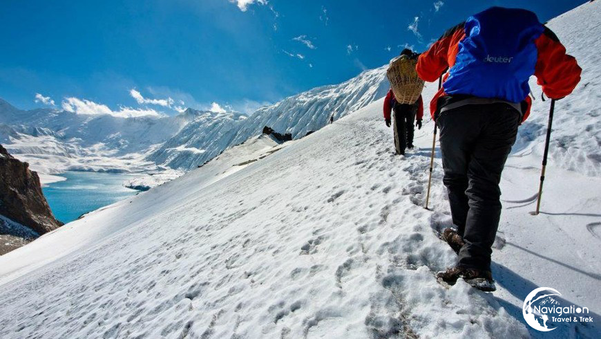
One of the toughest sections of the Tilicho Tal(lake) trek is the ascent from Tilicho Base Camp to Tilicho Lake, which is the highest lake in the world. On a path covered in snow and ice for most of the year, we will be climbing steeply uphill. We will arrive at the captivating Tilicho Lake after the arduous climb and appreciate a fantastic view of Mount Tarke Gyang, Gangapurna and the Khangsar Kang. After spending time by the lake, we’ll take the same route back to Tilicho base camp. Because the descent is just as difficult as the ascent, you must walk carefully and keep your speed steady.
Tilicho Lake and back to Tilicho Base Camp
Lodge
Breakfast, Lunch, Dinner
4919m
6hr
We leave Tilicho Base Camp and continue up the Marshyangdi Valley route to Yak Kharka. The route passes through the settlement of Khangsar and continues uphill alongside Tho-rung Khola. After traveling a distance, we ascend the breathtaking valley to Yak Kharka, a wide peaceful grassland. From Yak Kharka, you may enjoy the beautiful scenery of the surrounding mountains, including Tilicho Peak (7134m), Khatungkang (6484m), Chulu (6584m), and other peaks.
Yak Kharka
Lodge
Breakfast, Lunch, Dinner
4040m
7hr
Leaving Yak Kharka, we head to the foot of Thorong La pass, Thorong Phedi, the highest point on the Annapurna Circuit. From Yak Kharka, we climb gradually to a ridge before descending to the headwaters of the Marshyangdi and crossing via a covered wooden bridge. After climbing up the mountain, we follow a narrow trail across an unstable steep slope until we reach Thorong Phedi. A close-up view of Thorong Peak (6144m), Syagang (6026m), Khatungkang (6484m) and Purbung Himal (6590m) is seen from Thorong Phedi.
Thorong Phedi
Lodge
Breakfast, Lunch, Dinner
4450m
6hr
The climb from Thorong Phedi to Muktinath Temple across the Thorong La high pass (5,416m/17,756ft) will make for a remarkable trek. It is also one of the most challenging parts of the Annapurna Circuit trek, Thorong La Pass, it makes the most difficult sections of the trail. We will leave early this morning to cross Thorong La. As soon as you leave camp, the climb gets steep, but the views from the Pass are well worth it. Along with the Annapurna Range, the Himalayan Mountains will be visible in their entirety. We next make our way down to Muktinath(3800m/12,467ft), a Buddhist and Hindu holy site. 108 stone sprouts with water coming from the Kali Gandaki are what make the Muktinath Temple famous. Additionally, you may witness the 2,000-year-old perpetual flame that is present. Although the 1600-meter descent to Muktinath is difficult, the beautiful panoramas of Dhaulagiri make it all worth it.
Muktinath
Lodge
Breakfast, Lunch, Dinner
5416m
8hr
Beginning our trip from Muktinath to Jomsom, we will travel through the village of Jharkot, where we will explore the local monastery, the impressive Tibetan Herbal Medicine Center, and an old fortress that was once a palace. As we descend to Jomsom, which is at the foot of the Kali Gandaki River Valley, we gradually lose elevation. Jomsom is the entry point to Mustang and home to a major market area. We will also witness the beauty of the Kali Gandaki Valley and Kagbeni Village from Jomsom.
Jomsom
Lodge
Breakfast, Lunch, Dinner
2720m
5hr
We will take a one-day rest in Jomsom, as it is the last day of our memorable trek. We will be exploring the Jomsom and visiting some of the local monasteries, visiting the apple garden and enjoying the beauty of the Jomsom. At last, we will celebrate the last day of our trek by having a group dinner with all our staff members.
Jomsom
Lodge
Breakfast, Lunch, Dinner
2720m
3hr
We bid farewell to Mustang and take a 20-minute flight to Pokhara early in the morning. The rest of the day may be spent relaxing and seeing the city, or you can take a flight back to Kathmandu. You may rent a boat and explore the mysterious caverns or go sightseeing or go boating in the exotic Phewa, Rupa and Begnas Lake in Pokhara Valley. Even adventurous activities like bungee jumping and paragliding are possible. You will have the opportunity to shop for memories and enjoy the vibrant city’s nightlife.
Pokhara
Hotel
Breakfast
820m
1hr
Altitude Graph
Inclusion/Exclusion
The Cost Includes
- Three meals a day during the Trekking (Breakfast, Lunch and Dinner)
- Accommodations in Tea House/Lodge during the Trekking.
- Trekking Guide, assistant trekking guide for groups with 12 or more trekkers and a porter (Sharing by two clients) with Insurance, food and accommodations.
- Jomsom – Pokhara flight cost – including airport taxes.
- Proper First aid kit.
- Trekking permit fee.
- A TIMS card (Trekking Information Management System) is like a permit.
- All government, local taxes, and official expenses
- Company’s duffel bag will also be provided. (If needed)
- All essential official fees.
Service not included in the Price
- International Airfare.
- Your travel insurance.
- Excess baggage charge (weight limit 9 kg per person).
- Nepal visa fee.
- Any kind of drinks during the trek.
- Other items of personal expenses like hot shower, battery charge, telephone, porter, etc.
- Tips for the Guide and Porter(expected).
- Travel insurance that covers emergency high-altitude Heli – rescue and evacuation and health care costs (compulsory).
- Additional costs or delays due to circumstances beyond our control like bad weather conditions, itinerary modification for safety, government policy changes.
Useful Info
While trekking is possible throughout the year in Nepal, the weather is the most crucial aspect to take into account when considering a trek to Tilicho Tal Trek. The Tilicho Tal Trek is considered to be most enjoyable in the spring and fall seasons.
This region is more pleasurable during these seasons because the weather and temperature are comparatively better than in other seasons. These seasons are the most favorable time to discover and appreciate the stunning splendor of this region. Additionally, you have the opportunity to discover more about the way of life and culture of the inhabitants.
Send Request
You can send your enquiry via the form below.
Trip name: * TILICHO LAKE TREK